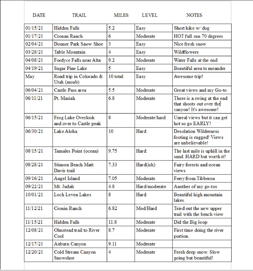
I finally got around to tallying my hiking stats for 2021. (scroll to bottom) With the fires it was a challenge so I went to the coast as much as possible. However, it was hard to escape the smoke even at the ocean on some days! In May, Alex and I took a Colorado/Utah road trip with the camper for a couple of weeks and explored lots of roadside trails, in Colorado, Moab, Arches and Canyonlands. Not much real hiking was done, just some meandering with a poodle riding in a backpack. Check out the vids!
Here are my 2021 stats for a total of 149.76 miles
PART 2!! Follow our favorite operatives as they fight the hoards of insurgents at Arches NP, discover mysterious ghost establishments in the desert, embark on an exploration assignment in Canyonlands, fly a reconnaissance drone in the Ruby Mountains among other classified missions.
The Mission: Deliver special package to Colorado Springs….contact operatives and other secret agents along the way for further instructions. You have two weeks to complete this mission.. Good luck.
HEAT INTOLERANCE: I’ve always been a wimp when it came to extreme heat. When I was 10 years old, I passed out on the neighbors driveway smack on my face while playing “tag” with the neighborhood kids in 100+ temps. I woke up to find my front teeth broken in half and passed out again! Fast forward to adult life, I seemed to tolerate the heat better as I became acclimated – I was young! The next time I became dangerously over-heated was when I was performing at a rodeo in the California foothills in August in my early 40s. The temps were well over 100 and I was wearing the usual rodeo garb of long sleeve spandex shirt, jeans, boots, thick leather chaps, cowboy hat, etc. I did this for years and rodeo season is always in the summer. It was HOT but I tolerated it.
Jan and Oreo Folsom Pro Rodeo
On this day, I remember going straight back to my horse trailer to strip off all of that garb in my tiny un-air conditioned dressing/tack room… a literal hotbox that was most likely over 120 degrees. I quickly changed into shorts and a tank top and I came out of that trailer staggering, almost puking and about to pass out. Thankfully, we had a couple of ER nurses on our drill team that started pouring cold on me to cool my core down. They gave me the nickname of”code 2″. ER code for “person passing out”. Later, the nurses bought me a little water spritzer fan to carry around with the words “Code 2” taped to it.
Now that I’m 60 and post Menopausal, my thermostat is all jacked up (as my husband calls it) and I go code 2 quickly. One would think that hiking in 85 degrees would be a nice day. But, 85 degrees at 8500 feet or more equates to 95+ in that thin air, especially if you are climbing a steep grade for a few miles in full sun and on granite slabs. I do hike with a light UV hiking sun umbrella which helps some.
On this particular hike, I was almost at a Code 2 just 1/8 mile from my destination. I became nauseous and I knew I was in trouble. When my body talks, I LISTEN! I immediately stopped in the shade, took off my pack and sat… for a really long time. I chugged my electrolyte enhanced water (that I had been drinking throughout the hike), ate a salt tab and munched on some salty snacks. When I felt I had re-set my body temp, I hiked that last short distance to the top.
The rest of my summer will most likely be kayaking and water sports until it cools down about 20 degrees in the high country.
I highly recommend reading the book “Death in the Grand Canyon” It was written by the Park’s doctor and river guide that worked in the Grand Canyon for many years. I learned a lot about heat exhaustion, hypothermia, and all of the other ailments and disasters at the park, etc. The stories are horrific, but a great learning tool for all who venture into the wild.
Here is the video of my HOT hike this week. No Dialogue, just views, an unbelievable array of wildflowers and some soothing music.
Take a minute and enter your email on the right to get alerts when I upload a new blog post! You won’t regret it, and I’m pretty sure Unicorns will appear at your door. I think… Not sure.. but pretty sure… give it a try!
It’s day onehundredeleventysomeningorother of the pandemic so onward I hike. On June 29, 2020, my niece Jenny (trail name Legs) and I head off from Wrights lake and find out way up the granite to Twin Lakes.
The trail goes on for miles deep into Desolation Wilderness, but since we took our time and really savored every moment in this area, we turned around at Lower Twin Lake which made for a 6.5 mile day.
The route up to the lakes is mostly granite so there isn’t much of a trail. We lost the trail many times, but having GPS on my phone, we were able to find the trail easily again. Going up, it was hard to see the cairns and the lines of rock in places that marked the route. Going back down was a piece of cake as you can see the cairns a lot better.
We were treated with many waterfalls, small lakes and exceptional views. I want to go back and explore further in, maybe with my overnight bag!
Because of the Pandemic, the Forest Service has suspended the need to get a day hike permit, but you still need one if you are an overnight backpacker.
It was a photo on one of the Northern California hiking FaceBook groups that brought my attention to this trail. In one photo was a monkey carved out of granite keeping a watchful eye over Lake Tahoe, and in the same post was a girl on a swing hung from the branch of a pine tree with nothing but sky and the lake surrounding her. She was literally in thin air. I had to see these things for myself. So, with my trusty map of the area, I plotted a course and called out to hiking pals Lee, “Bunny Hop” and “Pokey”
The trail starts just outside of Incline village. You can’t miss the parking lot at the end of the Tunnel View Cafe. It’s the same place where the old Ponderosa (Bonanza TV Show) theme park used to be. (It’s been gone since 2004) Take the Tunnel Creek trail for a couple of miles (all uphill) to see the granite monkey and swing. Continue on the uphill climb to the Marlette Flume trail for the most spectacular views of Lake Tahoe. Thankfully the Flume trail is flat. Beware, this very narrow trail is shared with bikes so be prepared to move out of their way! The bikers were courteous and at no time did I feel I was going to get run over or shoved off of the cliff. Those bike riders are braver than me as that trail is Narrow!
PS. Don’t forget to do the email sign-up thing on the right so you can get notified when I upload an episode!
On June 6, 2020 we had an awesome adventure ride with the California Quad and SideXSide Meetup Group out of the Sacramento Area. We did a loop of approximately 93 miles into the Lassen National Forest starting from Butte Meadows. We visited some very cool geological sites along the way ! Spoiler alert, and I get hit in the face with freezing hail as our windshield froze over! Yeah….roll-up windows and windshield wipers would have been nice!
It’s November 1, and the snow still hasn’t arrived in the Sierra. Join the Foothill Hilers as we take a nice 8.5 mile hike on the series of trails owned by the Tahoe Donner Land Trust. These trails are spectacular and have just enough ups and downs to give you a good workout. The views are incredible! Don’t miss the swing at Point Mariah!
It’s thrilling to soar over the Royal Gorge on a little board tied to a pine tree!
For a couple of years now,I’ve been sailing around the world…..from my couch! I’ve been obsessed with a few YouTuber channels called Sailing LaVagabonde, SV Delos, Gone with the Wynns, among a few others have taught me all sorts of sailing jargon and terminology not to mention I get to visit places I’d probably never see in my life (in person).
I can tell you what “taking a reef” means… or What a Spinnaker is… or the difference between a Ketch and a Sloop and a slew of other random sailing facts.. but I’ve NEVER stepped foot onto a sail boat – EVER – in my whole entire life until last weekend!
I was nervous , excited, afraid I would puke (drugs worked) and I waited for two whole months for this day to arrive! Would I do it again??? HELL YES! So, here we go on my first sail from Richmond CA to Angel Island and around the San Francisco Bay thanks to “Captain Ed” who graciously took a group of six out for a glorious day on the bay!
This wonderful trail in the Northern California Sierra, with abundant spectacular views is a must-do if you traverse around Donner Summit. The trail starts on the PCT just down the road from Donner Ski Ranch. You then take the Mount Judah loop trail from the PCT. Don’t forget to hike up to the summit of Donner Peak while on your way around and look out the “window” onto Donner Lake! WOW!
DON’T FORGET TO HIT THAT FOLLOW BUTTON AND PUT IN YOUR EMAIL ADDRESS SO YOU DON’T MISS MY NEXT AWESOME ADVENTURE!


You must be logged in to post a comment.