Tragedy at Frog Lake – Avalanche (My Thoughts)

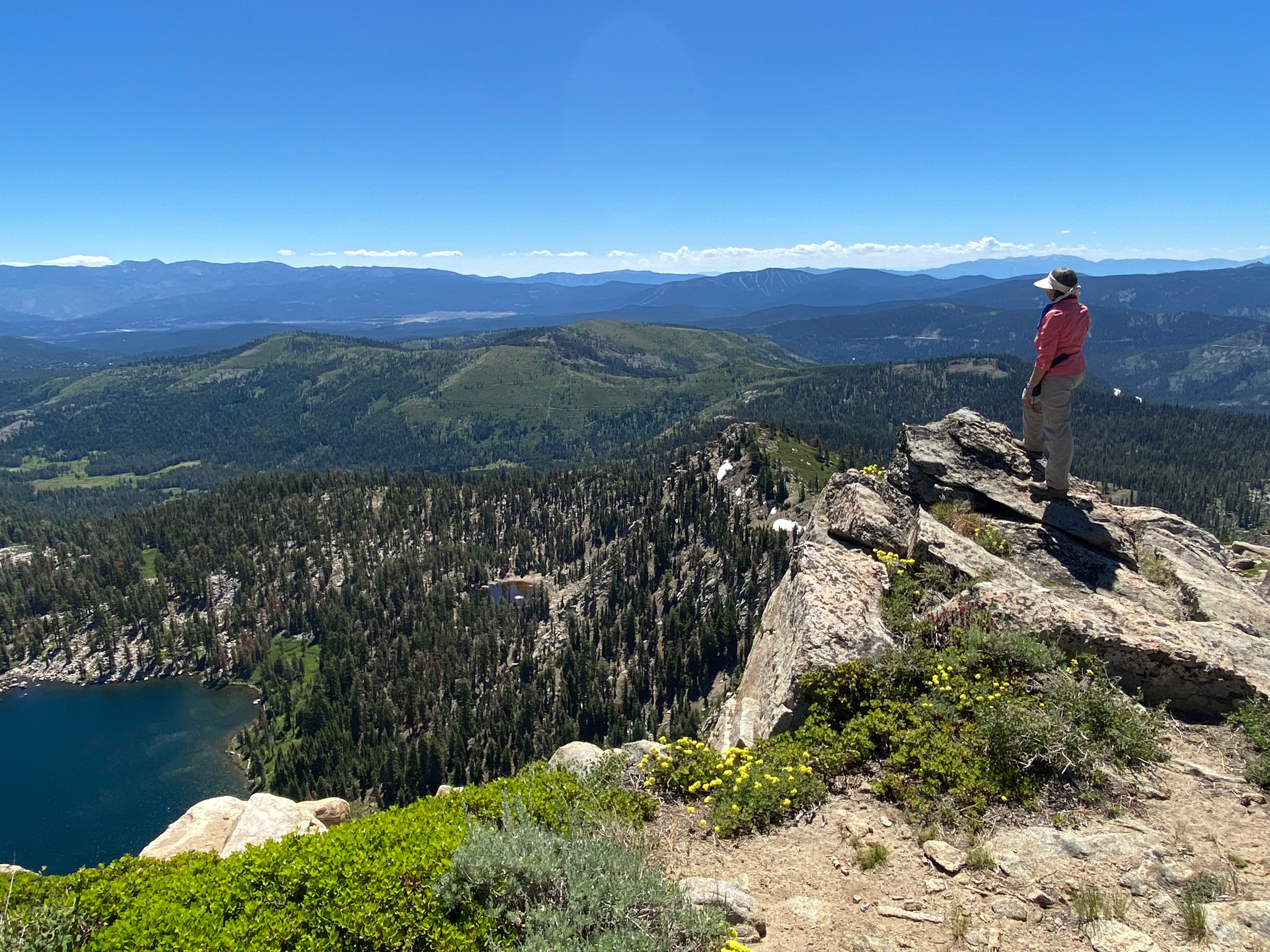
Me on Frog Lake Overlook.

When the Mountain Says No: A Memory of Frog Lake

I still remember the first time I hiked toward Frog Lake Overlook in the Sierra of Northern California.

It was summer. Blue sky. Warm sun. Wildflowers scattered along the trail like confetti. And even then — even in perfect weather — it wasn’t easy. The trail climbed steadily, the air thinned, and the slopes around felt big and exposed. It was hot, and I got overheated. At one point I honestly didn’t think I’d make it to the top, but I pushed forward.

I stopped more than once, hands on my hips, catching my breath and looking up at those towering ridgelines, thinking: This place is beautiful… but it’s serious. No joke.

In winter, that same beauty becomes something entirely different. Those open slopes fill with deep snow. Terrain that feels challenging in July turns avalanche-prone and unforgiving. It’s why the area is beloved by experienced backcountry skiers — and why it demands careful judgment every single time.

This week, that place took nine lives.

And I can’t stop thinking about how easily excitement, planning, and commitment can blur the most important decision we ever make outdoors: whether to go at all.

My husband was a private pilot for many years, and aviation teaches this lesson brutally and early. There’s a phrase pilots use: “get-there-itis.”

You plan the trip. Check the weather — all good. Drive to the airport. Then conditions change. You see holes in the clouds and start wondering: Can I get above this? Will it clear… or close in?

We’ve waited it out. We’ve diverted. We’ve cancelled entirely and driven home.

Because experienced pilots know something simple and hard:

The safest flight is the one you don’t take.

“Get-there-itis” kills pilots every year.

And sometimes, it shows up in the mountains too.

Forecasts had warned that the Sierra was about to be hammered with massive snowfall — feet upon feet in a very short time. Anyone familiar with the range knows what that means: unstable snowpack, hidden weak layers, and avalanche danger that escalates fast.

The Frog Lake huts are booked far in advance are NOT cheap and often more than a year out, with strict cancellation policies. That kind of reservation can quietly add pressure. After waiting that long, it’s human to feel like you have to go.

But mountains don’t honor reservations.

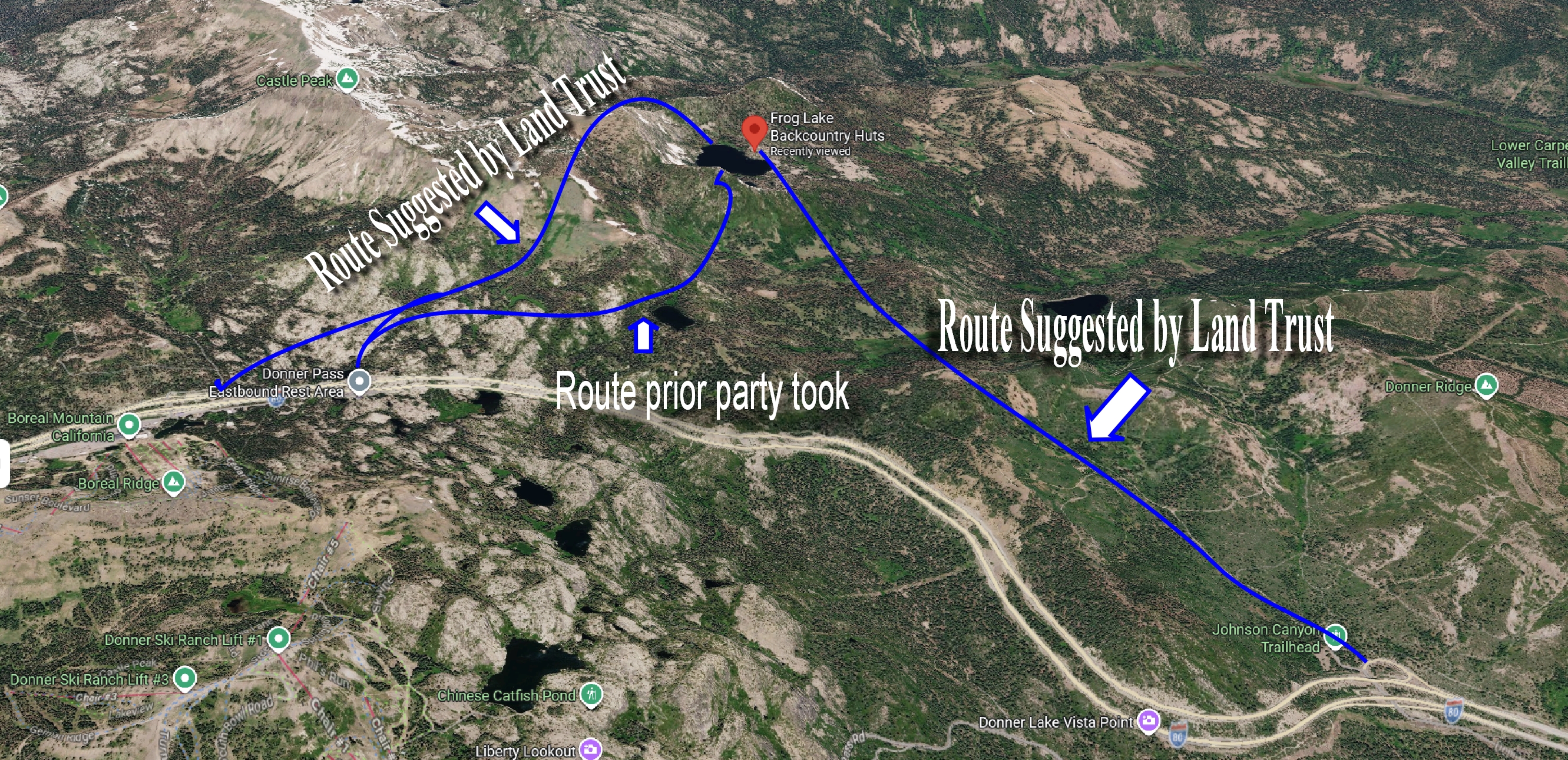
My perspective, from someone familiar with the area:

There are three routes out from the huts according to the Land Trust Website. Two of them cross the steep, avalanche-prone saddle, leading toward parking areas near I-80 and the Castle Peak trailhead — less than half a mile apart. Another option heads east along the flatter service road and heads east towards the Truckee area. Or, another option not mentioned by the Trust, is to cut over towards Summit Lake. With some backcountry navigation, that route can also be used to loop back toward the trailhead. In fact, another party reportedly used that approach to avoid the avalanche-prone saddle.

The huts themselves are modern, heated, and staffed with a full-time caretaker. Staying put could potentially have allowed rescuers to reach the group more safely once conditions improved. Skiing out over that saddle — especially during or just after a major storm — would be extremely dangerous. Also, the storm was raging and they were at risk of dying from exposure!

Of course, that’s easy for me to say from the comfort of home. I’m a backcountry hiker, not a backcountry skier. But I’ve done enough snowshoeing in that area to know how serious those winter conditions can be.

The Routes Suggested by the Tahoe Land Trust

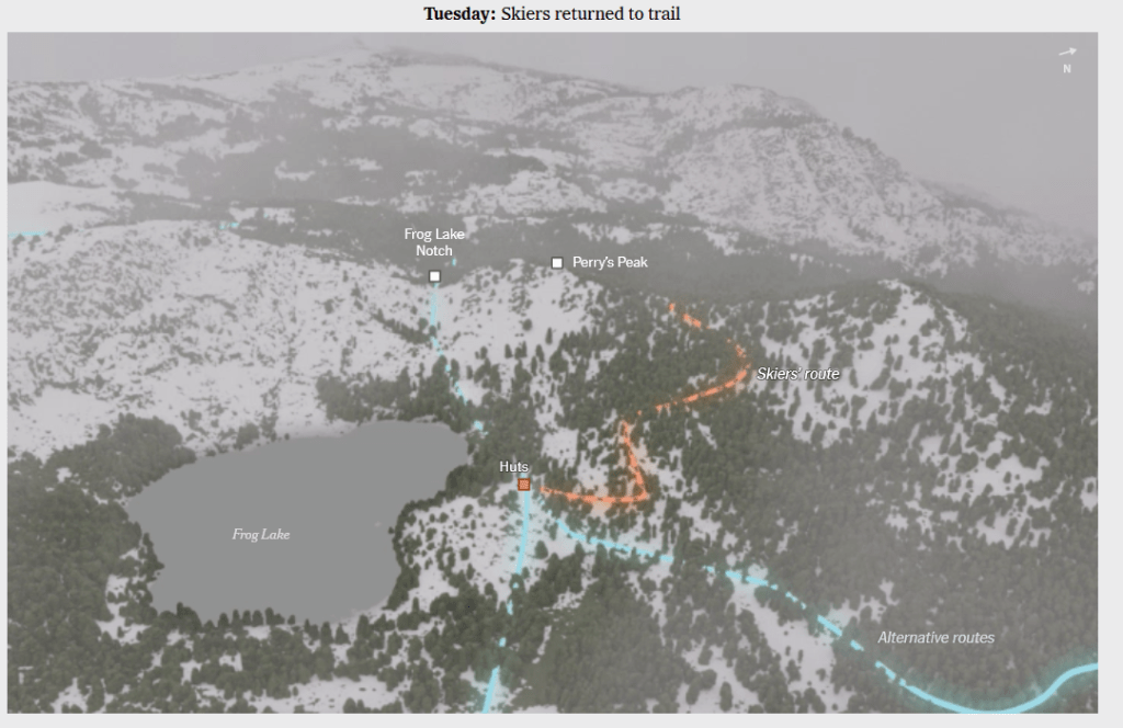
UPDATE: According to the New York Times Interview with survivors, the party took a whole other route as indicated below. This route took them directly under Perry’s Peak where the avalanche too place. (orange line) The regular route would have been Frog Lake Notch where they came in two days prior, but the guides decided not to use that route.

What we do know is what followed.

Search-and-rescue crews had to enter whiteout conditions and severe avalanche danger to reach the survivors. For hours, rescuers put their own lives on the line in terrain that was actively unstable. That’s what these teams do — but every risky decision in the backcountry ripples outward, placing others in harm’s way too.

This isn’t about pointing fingers. It’s about recognizing something deeply human.

We all feel the pull to keep going.
To finish what we started.
To not waste the opportunity.

But experience — real experience — teaches a quieter truth:

Turning back isn’t failure.
Waiting isn’t weakness.
Cancelling isn’t defeat.

Sometimes it’s:

The decision to stay in the hut and wait it out.
The willingness to cancel the trip altogether.

I think back to the summers of hiking to Frog Lake — the sunlight, the wildflowers, the sheer effort it took even in calm conditions — and this week’s loss feels even heavier.

Nine families are now living with the reality that the mountain will always be there…

…but their loved ones aren’t.

If there’s anything this tragedy leaves us with, it’s this:

The wilderness rewards skill and preparation.
But it demands humility.

And sometimes the most experienced thing we can do
is listen when the mountain says no.

Stay safe out there. The mountains are calling… but sometimes it’s best not to answer.

First Maltby Descendant’s Journey to Historic Maltby Lake

17:44Now playing

HISTORIC ACHIEVEMENT: First Maltby Descendant Conquers Maltby Lake

In the early 1940s, the owner of Maltby’s Resort at Upper Twin Lakes in Mono County, California, ventured high into the Sierra mountains. Hal Maltby, on a scouting trip for deer to benefit his lodge’s customers, stumbled upon a hidden gem: a pristine lake sitting above 9,000 feet that wasn’t marked on any Forest Service map.

Fast forward 81 years, Hal’s great-grandson, Carson, undertook the same challenging trek to locate this family legacy, now known as Maltby Lake. This journey not only retraced Hal’s footsteps but also forged a new chapter in their family’s history.

Watch the video, edited and narrated by me, to delve deeper into Hal’s discovery and Carson’s epic, albeit arduous, journey to Maltby Lake.

New Hiking Trail near South Lake Tahoe | California Ranch Move

My time is getting short in California! In between all of the house projects for the upcoming sale of the ranch and move to New Mexico, I’m trying to find some time to get Sierra hiking in. Here is a trail near South Lake Tahoe that I haven’t done before! This trail is considered moderate at 7.2 miles round trip and 1300 feet of elevation gain, but you are rewarded a nice cool lake to take a dip!

What’s in my Day Hiking Back Pack?

Even if I’m doing an easy 5 miler in the wilderness, I always carry the 10 essentials and MORE! After having to almost spend the night in the Lassen National Park wilderness completely unprepared after a short hike to a lookout tower, I learned a hard lesson! I now carry items to sustain me in the wilderness until help arrives. This could be hours or even days!
Disclaimer: This is what I carry. You may have different ideas! I’d love to hear them!

Here is the link to the fiasco I was involved in a few years ago where I almost had to spend the night in the freezing cold forest!

The Story about my (almost) night in the mountains!  

My Day pack is an REI Trail 40 and Here’s what’s in it! (NONE of the links are affiliate. All  are non-sponsored)

A word about navigation apps and what I use:

I rely on a few essential navigation apps, tested and trusted by hardcore mountaineers and thru-hikers. These apps provide reliable navigation and have been field-tested by the toughest adventurers. Here are my go-to  primary choices:

  1. Gaia GPS is a powerful app offering detailed topographical maps, weather data, fire information, private property boundaries, and many other useful layers. It’s widely used by serious backcountry hikers. While the free version offers many features, the paid version is highly recommended for those who frequently venture into remote areas.

  2. FarOut: FarOut is particularly valuable for the three long trails: the Pacific Crest Trail (PCT), Continental Divide Trail (CDT), and Appalachian Trail (AT). A one-time fee allows you to download the trail you hike most often—for me, that’s the PCT.

These are my secondary apps:

  1. AllTrails: AllTrails is excellent for researching and finding hiking trails. The paid version includes a cool 3D animated feature, plus up-to-date trail data from recent hikers, which is especially helpful during the spring thaw. However, be cautious with the navigation feature, as it has been known to be unreliable on backcountry trails.

  2. Wikiloc: Wikiloc is another useful app for researching trails and discovering new hiking destinations.

  3. PeakFinder: PeakFinder can be hit or miss when identifying peaks. It’s great when it works, but don’t rely on it in a moving car. The app is free.

Other Things I take:

Hiking Umbrella – Trekking Poles- Water Bladder-Cell Phone- Hat- hiking gloves- roll of duct tape wrapped around chapstick, garbage bag, toilet paper (pack out used!), Hand warmer, Smart water bottle, it fits the water filter, and A FRIEND! Don’t hike alone!

Here is what’s in my multi-night (backpacking) bag!

https://lighterpack.com/r/fxk0s3

My 2022 Hiking Stats

With my heat related issues, I’ve had to scale down my summer hiking. In the summer months the sun is almost straight above at 9:00am! The temps are already climbing into the 80s and it’s not even noon. In the high country where it’s nothing but granite and lots of uphill, its HOT! So, that means I need to be at the trail head at sunrise which is 5:30am, and that means leaving my house at 4:00am! If that’s what I have to do to keep hiking in the summer, then so be it! I’ll also be doing more Kayaking!

Advantages of the early morning mountain hike: No people and more wildlife! Win Win!

***There were a few trails which I hadn’t done before which are highlighted.

Rebel is the only one who is willing to get up that early!

2018 The year of Peak Bagging

As I was training for a big Pacific Crest Trail section hike, I decided to see how many mountains I could get to the top of! The section hike was cancelled because of forest fires, so I continued to climb peaks. I hope to climb even more peaks next year! I have new goals!

We are Fleas on a Dog.. but WHAT A DOG!

During all of my hikes over the Sierra the past few years, I’ve had soooo many questions about how and why things are the way there are, geologically speaking.  I’d see a huge lava outcropping and I’d wonder when that got there and how?  Was it blown to it’s current resting place from a distant volcano? Did it pop out of the ground from an ancient fissure?  Just how old are the Sierra anyway?

I’m finally taking some time to seriously study Geology.  I have some answers and my hikes are that much more interesting!   This Earth has been evolving for 4.6 billion years and we’ve only been here 200,000 years of it.  Heating up, cooling down, over and over again with many variations of life forms that have come and gone over the millions of years.  Continents moving around, and still on the move. The Hawaiian Islands are moving in a Northwest direction about 4 inches a year! Eventually, they will join up with Japan! Australia is moving Northward about 2.7 inches a year. All the plates are moving, some faster than others.  Don’t believe me? Study Geology!   I would love to drive to Australia..  Mountains pushing up and STILL getting higher.  Think Everest is high now? Just you wait!   What will be here a million years from now? Us? Something else?   Nothing?  Hmmm…..  things I think about when I hike!  Geology is COOL!

Today, we take a short hike up to an ancient lava flow plateau that was formed during the creation of the Sierra Nevada when the entire range was bubbling with volcanoes and molten lava being pushed up everywhere!!  Here is some interesting reading about the Sierra.

With winter around the corner, the trees are singing their songs and a warning that a big change is soon to come.

From Dreaming to SAILING!

For a couple of years now,I’ve been sailing around the world…..from my couch!  I’ve been obsessed with a few YouTuber channels called Sailing LaVagabonde, SV Delos, Gone with the Wynns, among a few others have taught me all sorts of sailing jargon and terminology not to mention I get to visit places I’d probably never see in my life (in person).

I can tell you what “taking a reef” means… or What a Spinnaker is… or the difference between a Ketch and a Sloop and a slew of other random sailing facts.. but I’ve NEVER stepped foot onto a sail boat – EVER – in my whole entire life until last weekend!

I was nervous , excited, afraid I would puke (drugs worked) and I waited for two whole months for this day to arrive! Would I do it again??? HELL YES!  So, here we go on my first sail from Richmond CA to Angel Island and around the San Francisco Bay thanks to “Captain Ed” who graciously took a group of six out for a glorious day on the bay!

AHOY!